The groundwater level at the site is an important factor not only for the construction of a house, but also for the construction of a septic tank, a well, a well for drinking and industrial water. It is imperative to determine in advance the level of the location of the waters, otherwise the owner of the site will face unpleasant surprises, the most serious of which is a negative impact on the foundation. Heating the house can lead to the constant presence of water in the basement, the foundation itself will begin to collapse. High groundwater levels can cause a house to not last long.
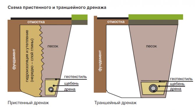
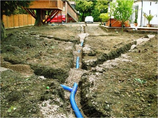
Trench drainage around the house
Therefore, the stage of checking the level of groundwater, the horizon of their occurrence, behavior during different seasons is necessary. It is possible and necessary to deal with high groundwater. There are many methods, among which drainage is optimal. If it is possible to choose another site where the soil has more suitable characteristics, it is better to prefer it. But if there is no other way out, then it is necessary from the very beginning to plan work to drain or lower the level of soil moisture so that it no longer presents any problems during the construction of houses, sewage systems, drinking wells.
What is groundwater level
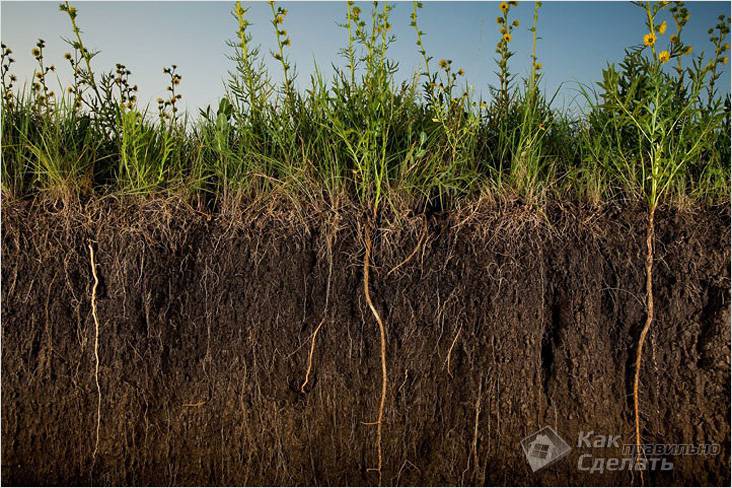
The groundwater level or GWL is the layer of soil that is completely saturated with water. This layer mainly contains rocky water-impermeable rocks. This layer has certain seasonal fluctuations and depends on the level of moisture it contains.
Dry periods can not only dramatically lower the level, but also completely dry out the aquifer. However, with the arrival of spring and the melting of snow, as well as during prolonged rains, the layer quickly recovers.
These level fluctuations can be quite perceptible. Therefore, it is important to know the average and how to determine the groundwater level at the site yourself. Since, at their maximum rates in spring and with heavy rains, these waters can lead to flooding of the site.


Improving soil composition
Soil with a close groundwater table, and even more so swampy soil, is usually quite poor, and if you manage to dry it, you will still have to improve it before you plant plants in this area. In addition, the soil must be checked for pH level: it is possible that the soil on the site is highly acidic. Then, before winter, you will need to add from 300 to 400 g of lime per square meter or the same amount of chalk, dig everything thoroughly, and in the spring measure the pH level again, and do this until the soil becomes neutral.
Further, ideally, on top of the existing soil, you need to pour imported soil. Thus, you will raise the site and increase its fertility.
Further, the site must be dug up by mixing the soil and adding dolomite flour in the amount of 300 g per one hundred square meters of land. Before planting seedlings (if planting is in the spring, then autumn fertilization is just ideal), you need to make 250-300 g of wood ash per square meter, a bucket of humus and a teaspoon each with a pea of superphosphate and potassium sulfate (all this is for digging , even if you have to dig up the site again).
Types of groundwater
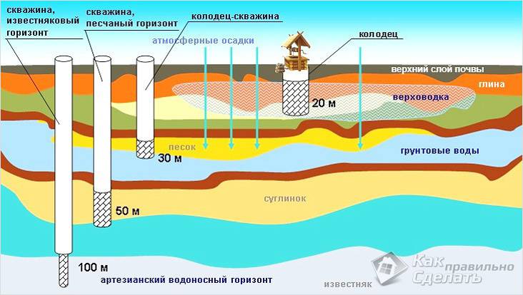
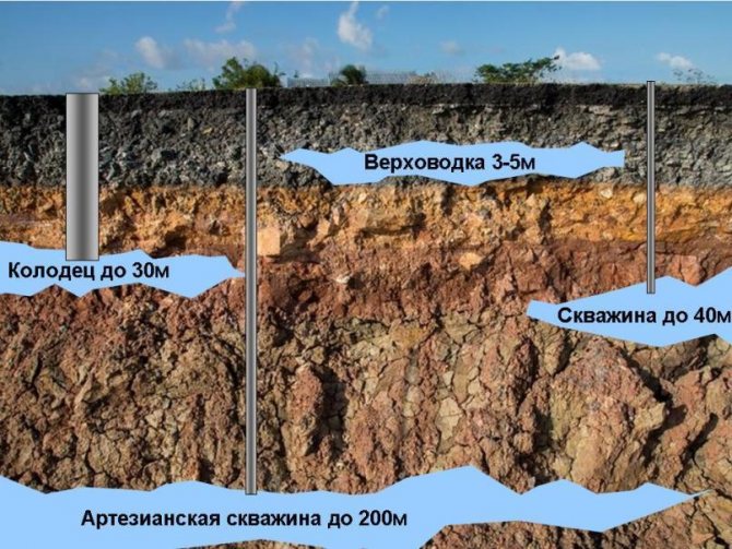
Groundwater falls into three categories:
- Supreme... Their depth starts at about one and a half meters and ends at two and a half meters. With prolonged periods of drought, they can dry out.
- Free-flow... These waters are several meters deeper than the first layer. They are immediately followed by the first layer of waterproof rocks.
- Artesian... The deepest layer of groundwater, which is sandwiched between two layers of impermeable rocks. The depth of occurrence varies from terrain and can reach more than a hundred meters.
Another striking example of the close occurrence of groundwater Source


Applications
A variety of situations may require level determination. In the construction industry, this applies to the technology of pouring the foundation. In horticulture, this kind of intelligence helps to take early action against possible flooding.
Building
When water is close to the surface, as a rule, pile-type foundations are erected.
In addition to the type of foundation, the type of waterproofing used also depends on the level of groundwater.
In addition, a specific drainage system scheme is calculated.
High UVG prevents the construction of basements or observation pits in garages. First, it will be necessary to carry out measures to lower the level and drain excess water, which is quite expensive for the developer.
Gardening and home gardens
For the root system of plants, one of the destructive factors is constant waterlogging. For this reason, in places where gardens are laid out, the upper limit level should not exceed one and a half meters. Permanent flooding also has a negative impact on garden crops.
With a high ground level, it will be necessary to carry out work to lower the level, use drainage ditches.
On our website you can find contacts of construction companies that specialize in foundations and water supply, sewerage, including the determination of the groundwater level on the site. You can communicate directly with representatives by visiting the Low-Rise Country exhibition of houses.
Water supply
Knowing the GWL, it becomes possible to accurately calculate how deep the well for drinking water should be. The type of water intake system largely depends on this: it can be a well or a well.
Sewer and drainage systems
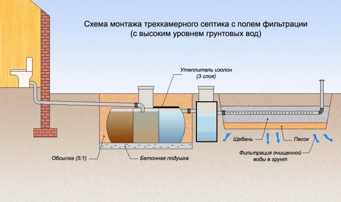
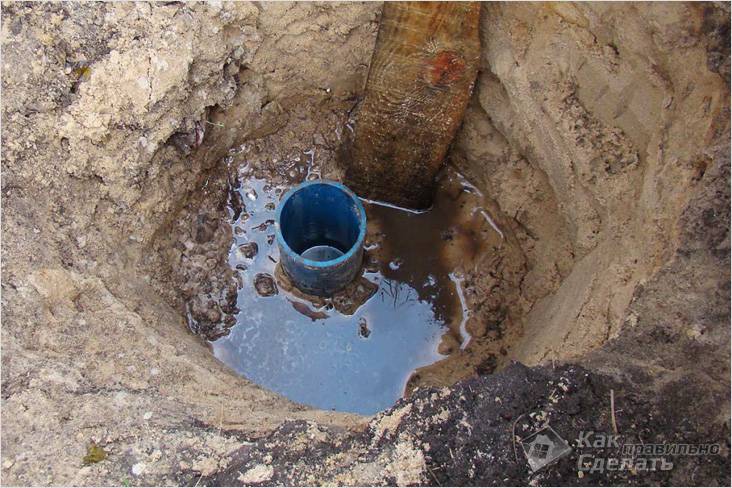
The depth of the pit for sewage waste, as well as the filtering well, directly depends on the hydrocarbon gas. To carry out such work, there are corresponding regulatory documents.
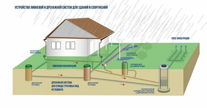
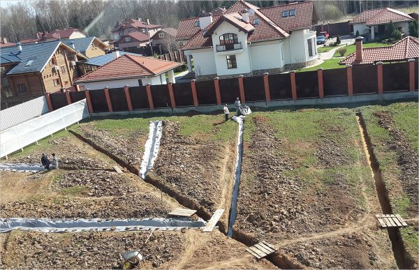
Storm sewerage and drainage of the site Source i2-
Rules for planting trees and shrubs
When planting trees and shrubs in soil with high water levels, there are some nuances that should be followed to expect a good harvest.
Firstly, not all crops will take root on swampy soils. Shrubs that love acidic soils are best suited for them: blueberries, lingonberries, blueberries, currants, raspberries and others. Planting moisture-loving trees can also be a good way out of this situation. These include willow, birch, rowan, plum, peach, cherry. Apple trees should be planted on a dwarf scion, due to the fact that their roots do not lie deeper than 60 centimeters. But grapes or apricots are not suitable for such garden plots.
Secondly, the method of planting plants is different.
To begin with, with the help of a dug hole with a depth of 1 to 2 meters, they find out how close the water has come. If its level is no higher than 60-70 centimeters, then this soil is suitable for planting fruit trees.
At the second stage, the pit is expanded to 1-1.5 meters, and the depth is reduced to 30-40 centimeters. The main task when planting is to make the roots grow not in depth, but in width. This can be achieved with a sheet of metal, slate, or thick planks placed on the bottom of the pit. One of the options is concreting the bottom.
After that, a drainage layer is laid in the pit. These can be large stones or broken bricks.Further, fertile soil is poured so that a hill is formed, the height of which varies from half a meter to a meter (depending on the culture of the tree). It is in this hill that the seedling is buried. The last step is to make the crate, which is necessary so that the landing hill is not washed away by the rains.
Further care is no different from caring for commonly planted fruit trees and shrubs.
Methods for determining HCG
Understanding the importance of data on HCG and its changes, it is equally important to know what methods can be used to solve this problem. Modern experts use several methods to determine the level of groundwater occurrence.
Archival research
As a rule, residential areas are located in areas that have already been developed for a long time. Quite often, surveys regarding the definition of GWL have already been carried out earlier and the corresponding maps have been drawn up. Therefore, the solution to the question - how to determine where to drill a well for water on the site, may lie in the appeal to archival documentation.
Such documents are obtained from specialized organizations whose activities are to monitor the situation in a particular area from a hydrogeological point of view. With this method, a certain difficulty can arise.
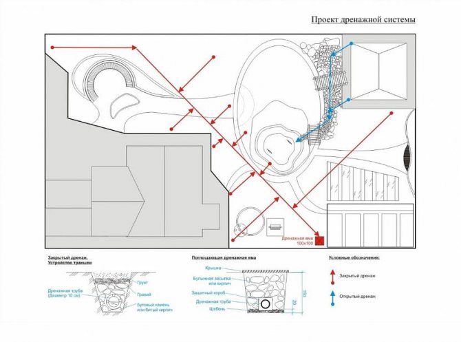
Deep drainage scheme of the site Source
This might be interesting! In the article at the following link, read which septic tank is needed for high groundwater.
Most of these maps belong to the period of the USSR. At that time, a special program of geological exploration of the territory was operating on the territory of the country. Control wells were drilled in five kilometers increments.
The scale of the maps themselves is one to two hundred thousand, which is displayed on paper as - one centimeter is equal to two kilometers. Since a standard suburban area is about ten acres, the use of such maps gives very approximate results.
Direct on-site data collection
Interviewing local residents and measuring the depth of local wells and boreholes gives quite reliable results on the depth of groundwater. In this case, it is necessary to take into account both the general relief of the area and a specific land plot.

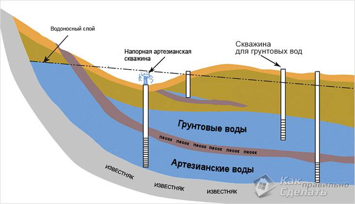
Deep artesian water-bearing strata
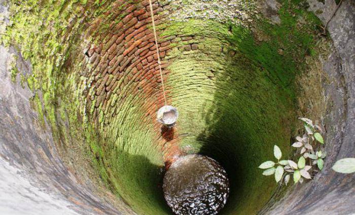
Having an artesian well in the country is the dream of any owner. It should be noted that the dream is difficult to fulfill. In accordance with the requirements of the Subsoil Law, such water intake is subject to compulsory licensing, and the sanitary protection zone of the well is at least 30 meters from it in any direction. Thus, the exclusion zone will be about 40 acres, and any type of economic activity is prohibited on this territory. Will this land be sold to you is a big question and how much will it cost? Although there are many places in Russia.
A choice is possible when solving the problem - to drill a collective artesian water intake for a small village, then the costs will not seem excessive.
In this case, the depth of a well for water can fluctuate from 70 to 200 meters; drilling to such depth horizons is quite a common practice. The quality of life-giving moisture from such wells, as a rule, turns out to be very high, it is transparent and tasty, which is not surprising with such a thickness of the filtering layer. The hydrogeological map of the area can provide information on the significance and quality of water in the reservoir.
Separately, it is worth mentioning the gravel aquifer. Drilling in such an environment is very difficult, the most productive is the process when flushing. But if clay mixtures are used, well clogging is very significant and will require prolonged pumping, even if the water is supported by internal pressure in the formation. A well-penetrated layer gives a good debit and tasty water.
Video description
How the drainage of a garden plot with a high GWL takes place, you will learn from this video:
Vegetation observation
This method can be attributed to folk methods, but it also has the right to life and provides primary data that can be taken as a starting point. The method is rooted in deep antiquity, since it is found in the description of ancient sources. Some plant species serve as an indicator of the proximity of water.
The following plants can suggest that the water is very close:
- willow and poplar - from one meter;
- horse sorrel - from two to three meters;
- mother-and-stepmother - from one and a half meters;
- alder - from three meters;
- wormwood - from three to five meters.
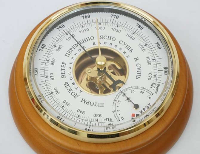
Classic barometer Source
It might be interesting! In the article at the following link, read how to drain the foundation with a high ground water level.
Instrumented Methods
When using various instruments and tools, there are three methods for determining the GWL. This technology is called leveling and is performed:
- Barometric way... When working, a barometer is used with which the pressure is measured in the investigated area. The control point is the measurement of the pressure at the water surface of the nearest large body of water. A step on the scale of the device of one millimeter gives a drop of thirteen meters on the ground.
- Geometrically, in which a classic level and measuring sticks are used.
- Hydrostatic method... It is based on the principle of work of communicating vessels. To use it you need a hydro level.
It is worth noting that some "experts" propose to conduct echo-location of the area, claiming that this will help determine the level of groundwater. However, this is not quite true. The sonar can only find voids in the rock mass, but not the fact that they will be filled with water.
Also, do not trust the various "devices" that are actively offered by sellers from China. They will not help conduct any research. On the contrary, professional hydrogeologists warn that all this is akin to the work of dowsers.
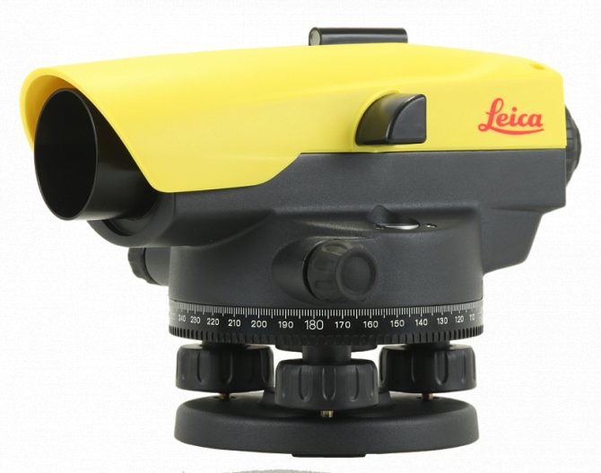
Optical level without stand Source prom.st
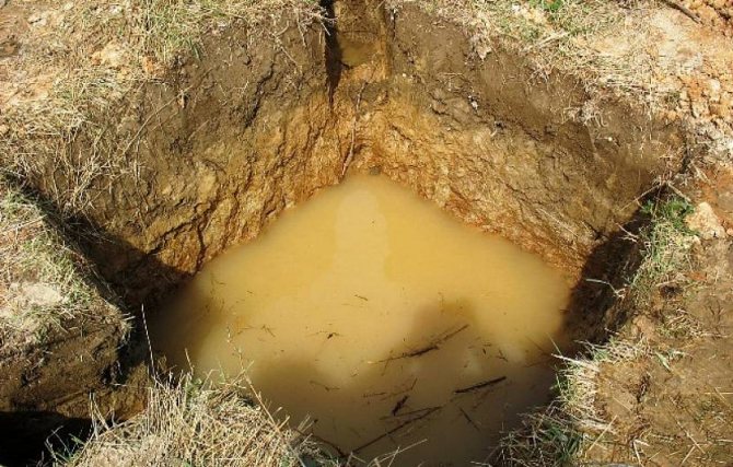
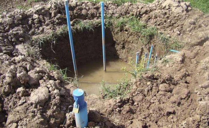
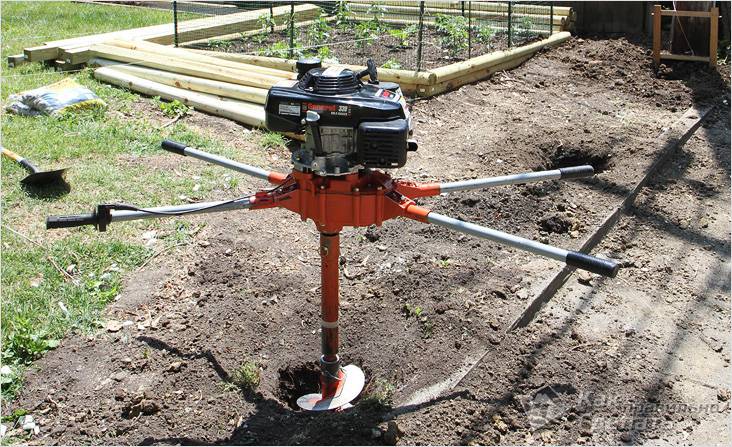
Well drilling method
This method is most indicative for construction work. However, it will not help to suggest how to determine the water in the area for the well, since the drilling depth is not great. To use the method, no complicated technique is needed, an ordinary garden drill is enough.
Drilling is carried out three meters at several locations in the surveyed area. Several wells are necessary due to the unevenness of the groundwater supply. After drilling, for a certain period, monitoring of the dryness of the wells is carried out.
If water does not appear for several days, then this signals a deep finding of groundwater. Therefore, on the site you can build a standard foundation and build basements. Otherwise, you will have to look for opportunities to lower the groundwater level at the site.
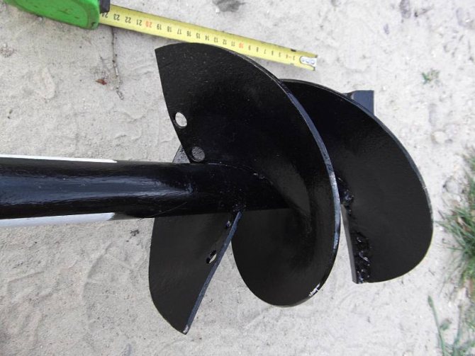
Manual Drill Auger Source
It might be interesting! In the article at the following link, read what a drainage inspection well is for.
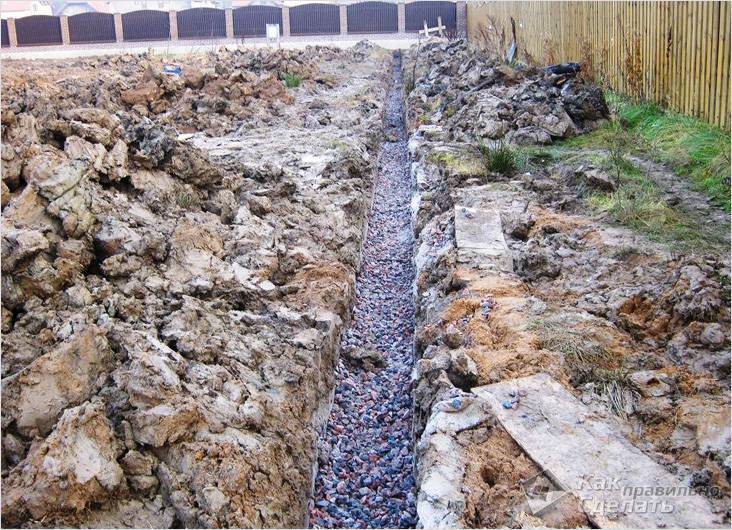
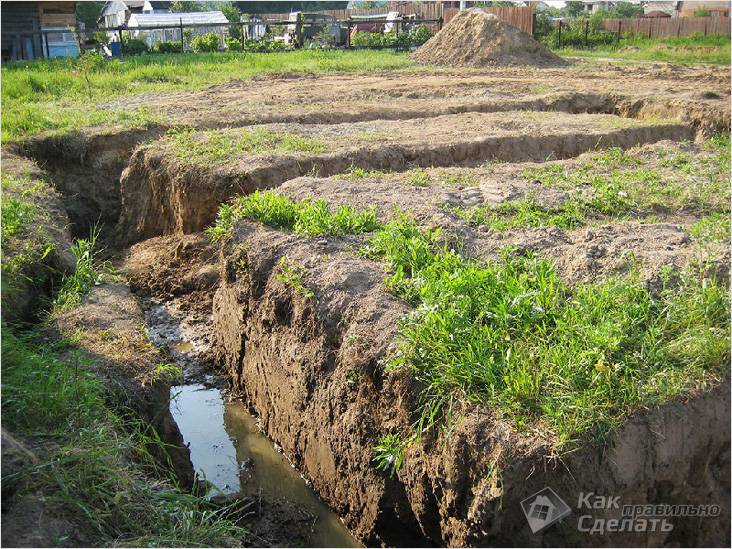
We equip drainage channels in the future garden
Drainage canals need a whole network, they must literally encircle the site, you can even throw bridges over these canals and move along them to the main place, which will gradually drain.
Before constructing drainage channels, you need to determine in which direction your site is leaning. After determining, try to make sure that the channels are directed exactly in the direction of the slope. After digging them, be sure to lay them all out with a thick plastic wrap, it will protect the channels from overgrowing. Ultimately, all channels should converge in one place, forming something like a pond, which will serve as an evaporator of excess moisture. It will be possible to draw water from it for irrigation.
Important! The depth of the canals you dug should be no less than the depth to which the soil usually freezes in your region, for example, in the center of Russia, the soil can freeze up to one meter.
In the event that it is not possible to build a drainage pond, then make at least a drainage well, also directing all the channels from the site into it. But in this case, you will have to use a pump, which from time to time will need to pump out water from the site, draining the well.